
Lesson 1: Introduction ✓
|
1. Course outline and Introductions
2. Survey |
Lesson 2: Intro to Geography ✓
|
1. What is geography, share with a partner then run up to board and record one idea
2. Introduce Geography -set up a maze in the room, darken the room and have them go through the maze of desks. How does this activity relate to geography? 3. In groups of 4, List every country they know in 5 minutes. Count how many they have. 3. Group with most reads list, everyone crosses off the countries they have, Group with most “unique” countries at the end will win a small prize. 4. Show them Yakko nations of the world song clip, see if he missed any, watch again to see. If they are right they get a starburst (see clip below) 5. Show NFB O Canada clip (see below) 6. What places do you recognize (Shout out). What does this clip show us about Canada? Have you been to them? What did you do there? How is the area different from Victoria? What places do you know in Canada? Play a game to see how many provinces/capitals teams can label on the map. Try a plate of food from four regions of Canada |
Lesson 3: Mapping✓
|
1. Powerpoint on how mountains and valleys are created.
Clip for Mt. St. Helens (Left) 2. Define key terms in chapter: A. Region: an area with similar characteristics (get kids to give examples) B. Vegetation: Plants that grow naturally in an area (examples) C. Topography: The shape of the land (mountains, hills, plains) D. Climate: The temperature and precipitation (moisture) over time in an area. 3. Hand out map assignment and explain, each day we will work on it and have a mini lesson. 4. Remind them of Map Rules:
| ||||||||||||
Lesson 4: Latitude and Longitude ✓
|
1) Review how mountains are formed and key terms (Region, Topography, Vegetation and Climate) 2) Show PowerPoint on Latitude and Longitude while students take notes 3) Balloon activity, to review longitude and latitude 4) Review rules for the map 5) Work on map. Label physical regions, and provinces 6) Do Appalachian region together on back of map, read with them and give example of a good summary. Appalachians: East Coast Topography -Old mountains, so low from erosion, fold mt. -Fertile plateaus (flat high grounds) and river valleys -Many rivers -Coal, oil and gas are resources Vegetation -Coniferous and deciduous forests Climate -Cold winters because of Labrador Current -Warm summers because of Caribbean current | ||
Lesson 5: L/L Review & Symbols
|
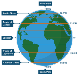
1. Review, lat. Long, and prime meridian. Tropic of cancer and Capricorn, equator, Greenwich mean time, International dateline by going outside and using yarn to create a human globe.
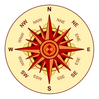
Directions: 1. Stand in a circle 2. Point out East, West, North, South. Discuss where we get morning sun and where we get afternoon sun. Get them to decide where the equator should go. Give those two students red yarn. 3. Ask them where the Tropic of cancer and Capricorn should be, those students , get Yellow yarn. 4. Give Blue Yarn for the Arctic and Antarctic Circles 5. Give green yarn for Prime Meridian/Greenwich Mean time 6. Do a couple of lines of latitude and longitude in black 3. PowerPoint on compass rose/map symbols, (powerpoint says where to take notes) 4. Game on PowerPoint (Guess that symbol) with prizes 5. Work on video | ||||
Textbook Work:
193- 179 Activities
Geography Quiz ( /40)
The Land
- Volcanic Mountains vs Fold Mountains
- Examples
- How are they formed?
- What are the qualities of a mountain?
- Glacier Erosion
- Examples
- How does it happen?
- Compass Rose
- N,S,E,W etc. know how to read one and the directions
- Latitude and longitude
- Which is which
- Know qualities of each (i.e. which have same length, angles)
- label specific/special lines
Canada
- Canadian provinces and capitals (label)
- Hudson's Bay/Oceans (label)
- Canadian regions (label)
- Know details about each area to answer short answer questions (topography, climate, geography)
example:
1) Would you rather live in _______________________ or ______________________explain why (5pts)
2) If you were going to build an attraction in Canada what region would it be in and why? How would you use the region to your benefit?
